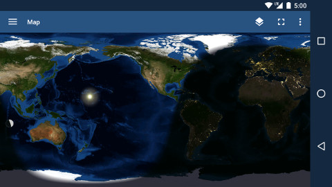
Watch the passage of time: a photo-realistic, global, real-time map of daylight and darkness, clouds and seasons. It's never the same view twice as the day/night line changes position from hour to hour, and changes shape from month to month. The interactive map can be accessed from the main TerraTime navigation menu; or, like the globe, it can be used as a live wallpaper on the home screen of any Android device (click if you need help with this).
The map is built up from the following layers, all of which are created from either current satellite imagery or astronomically-accurate computer simulations. Except for the base layer, you have the option of hiding or showing any that you choose:
- Current-month surface imagery (base layer)
- Ocean depths (bathymetry)
- Polar sea ice
- Clouds
- Night-time shadow
- City lights (on the night side)
- Sun (location where currently overhead)
- Moon (current phase and overhead location)
*To conserve bandwidth, TerraTime uses a single, cached cloud image by default. If you'd like the app to download cloud imagery from current satellite photos instead, simply turn off the Work offline option in the app's Settings.